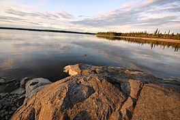
Lake Matagami facts for kids
Quick facts for kids Lake Matagami |
|
|---|---|
 |
|
| Location | Baie-James, near Matagami, Quebec |
| Coordinates | 49°52′00″N 77°26′47″W / 49.86667°N 77.44639°W |
| Primary inflows | Allard River, Bell River, Gouault River, Waswanipi River. |
| Primary outflows | Nottaway River |
| Basin countries | Canada |
| Max. length | 43 kilometres (27 mi) |
| Max. width | 14 kilometres (8.7 mi) |
| Surface area | 236 square kilometres (91 sq mi) |
Lake Matagami is a lake in Jamésie, in Nord-du-Québec, in Quebec, in Canada. It is located just north-northeast of the town of Matagami.
Geography
Located in a marshy area of northern Quebec, the lake created by the meeting of the rivers Allard, Bell, Gouault, the Canet and Waswanipi. This lake is about 14 kilometres (8.7 mi) wide, with a length of 43 kilometres (27 mi) and an area of 236 square kilometres (91 sq mi).
History
Matagami Lake has long been used as a transportation route in the fur trade from the 18th century to the 20th century by the Hudson's Bay Company.
Toponymy
In Cree, "matagami" means "meeting of waters", in reference to the large rivers that join.
See also
 In Spanish: Lago Matagami para niños

All content from Kiddle encyclopedia articles (including the article images and facts) can be freely used under Attribution-ShareAlike license, unless stated otherwise. Cite this article:
Lake Matagami Facts for Kids. Kiddle Encyclopedia.

