Lake Lawtonka facts for kids
Quick facts for kids Lake Lawtonka |
|
|---|---|

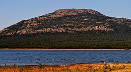
East Shore of Lake Lawtonka at Sunset, with Canada Geese. Mount Scott in Background. Photo by Schyler, August 1, 2011.
|
|
| Location | Comanche County, Oklahoma |
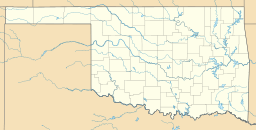
| Coordinates | 34°45′21″N 98°30′15″W / 34.7559°N 98.5041°W |
| Type | reservoir |
| Primary inflows | Medicine Creek |
| Primary outflows | Medicine Creek |
| Catchment area | 92 sq mi (240 km2) |
| Basin countries | |
| Managing agency | City of Lawton |
| Built | 1905 |
| Surface area | 2,325 acres (941 ha) |
| Average depth | 23.6 ft (7.2 m) |
| Max. depth | 58.4 ft (17.8 m) |
| Water volume | 63,000 acre⋅ft (0.078 km3) |
| Shore length1 | 19.2 mi (30.9 km) |
| Surface elevation | 1,345.55 ft (410.12 m) |
| Settlements | Lawton, Medicine Park, Meers |
| 1 Shore length is not a well-defined measure. | |
Lake Lawtonka is a lake in Comanche County in the state of Oklahoma in the United States.
The lake is 2 square miles (5 square kilometers) in area. It is formed by a dam 60 feet (18 meters) high and 375 feet (114 meters) long across Medicine Bluff Creek. The lake provides the water supply for Fort Sill and Lawton to the south.
Recreation
Fishing and camping facilities are maintained by the City of Lawton, Oklahoma.
Images for kids

All content from Kiddle encyclopedia articles (including the article images and facts) can be freely used under Attribution-ShareAlike license, unless stated otherwise. Cite this article:
Lake Lawtonka Facts for Kids. Kiddle Encyclopedia.


