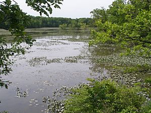
Lake George (Hobart, Indiana) facts for kids
Quick facts for kids Lake George |
|
|---|---|

Lake George, Indiana
|
|
| Location | Hobart, Lake County, Indiana |
| Coordinates | 41°31′41″N 87°16′26″W / 41.52806°N 87.27389°W |
| Basin countries | United States |
| Managing agency | Hobart Parks and Recreation Department |
| Surface area | 270 acres (110 ha) |
| Max. depth | 14 ft (4.3 m) |
| Surface elevation | 604 ft (184 m) |
Lake George is a mill pond on Deep River in Hobart, Indiana, in the United States.
Lake George was formed when George Earle constructed a dam on Deep River to power sawmills and gristmills. The lake is fed by several small streams, including Deep River, the largest, and Turkey Creek. It is approximately 5 km (3.1 mi) long, 300 m (980 ft) at its widest, and has a surface area of 270 acres (110 ha).
The lake is a popular site for recreation in Hobart. Two local parks and multiple residential areas border the lake and Deep River.
Since its creation, the lake has accumulated a large amount of sediment in its upstream wetland areas that washes into the lake during rainfall events, leading to a decrease in water quality. In 1995, the U.S. Geological Survey carried out a survey of the lake to measure the thickness of sediment. As a result of this survey, the lake was dredged in 2000, removing nearly 600,000 cubic yards of sediment.


