Laghouat Province facts for kids
Quick facts for kids
Laghouat Province
ولاية الأغواط
|
|
|---|---|

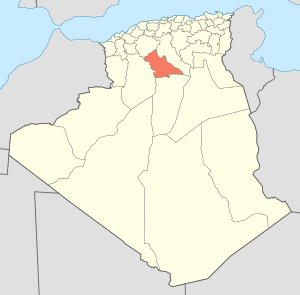
Map of Algeria highlighting Laghouat
|
|
| Country | |
| Capital | Laghouat |
| Area | |
| • Total | 25,057 km2 (9,675 sq mi) |
| Population
(2008)
|
|
| • Total | 477,328 |
| • Density | 19.0497/km2 (49.3385/sq mi) |
| Time zone | UTC+01 (CET) |
| Area Code | +213 (0) 29 |
| ISO 3166 code | DZ-03 |
| Districts | 10 |
| Municipalities | 24 |
Laghouat is a province (wilaya) in central Algeria. The name means "the oases". The capital is Laghouat. Other localities include Aflou, Ain Madhi, Kourdane and Makhareg.
Contents
Divisions
The province is divided into 10 districts. There are also 24 communes or municipalities.
Districts
- Aflou
- Aïn Mahdi
- Brida
- El Ghicha
- Gueltet Sidi Saâd
- Hassi R'Mel
- Ksar El Hirane
- Laghouat
- Oued Morra
- Sidi Makhlouf
Images for kids
See also
 In Spanish: Provincia de Laghouat para niños

All content from Kiddle encyclopedia articles (including the article images and facts) can be freely used under Attribution-ShareAlike license, unless stated otherwise. Cite this article:
Laghouat Province Facts for Kids. Kiddle Encyclopedia.


