Laclede's Landing, St. Louis facts for kids
Quick facts for kids |
|
|
Laclede's Landing
|
|

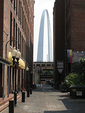
The Gateway Arch viewed from the Landing
|
|
| Lua error in Module:Location_map at line 420: attempt to index field 'wikibase' (a nil value). | |
| Location | Roughly bounded by Washington, N. 3rd, Dr. Martin Luther King Dr., and the Mississippi River, St. Louis, Missouri |
|---|---|
| Area | 22 acres (8.9 ha) |
| Built | 1780 |
| Architectural style | Late Victorian, Federal |
| NRHP reference No. | 76002262 |
| Added to NRHP | August 25, 1976 |
Laclede's Landing, colloquially "the Landing", is a small urban historic district in St. Louis, Missouri, United States. It marks the northern part of the original settlement founded by the Frenchman Pierre Laclède, whose landing on the riverside the placename commemorates. The buildings in the area date from later periods, however.
Located just north of Gateway Arch National Park (separated by the overland spans of the Eads Bridge) on the Mississippi River front, the Landing is a multi-block collection of cobblestone streets and vintage brick-and-cast-iron warehouses dating from 1850 through 1900, now converted into shops, restaurants, and bars. The district is the only remaining section of St. Louis' 19th-century commercial riverfront.
Transportation
Laclede's Landing has many cobblestone streets. It is adjacent to the Eads Bridge, and Interstate 44 (I-44 does not run over the Eads Bridge). On the Eads Bridge there is the Arch-Laclede's Landing MetroLink Stop. Laclede's Landing once housed Metro's (the local transit agency) headquarters.

