La Niña facts for kids
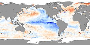
La Niña is a coupled ocean atmosphere phenomenon that is counterpart to El Niño. The name means "little girl" in Spanish. La Niñas are often, though not always, preceded by an El Niño phenomenon. Weather patterns in the United States are usually different than during El Niño years. During La Niñas the Atlantic hurricane season produces more intense storms than normal.
Contents
Recent history
A strong La Niña hit in 1988-1989. A weaker one took place during 1995. An extended strong La Niña spell took place from 1998 to 2000, followed by neutral periods between 2000 and 2002. A more recent La Niña happened in 2007-2008, followed by neutral conditions in 2008-2009.
Regional impacts
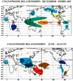
Observations of La Niña events since 1950, show that impacts associated with La Niña events depend on what season it is. However, while certain events and impacts are expected to occur during events, it is not certain or guaranteed that they will occur.
Africa
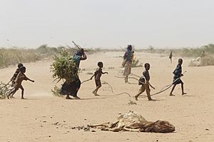
La Niña results in wetter-than-normal conditions in Southern Africa from December to February, and drier-than-normal conditions over equatorial East Africa over the same period.
Asia
During La Niña years, the formation of tropical cyclones, along with the subtropical ridge position, shifts westward across the western Pacific Ocean, which increases the landfall threat to China. In March 2008, La Niña caused a drop in sea surface temperatures over Southeast Asia by 2 °C. It also caused heavy rains over Malaysia, the Philippines, and Indonesia.
North America
La Niña causes mostly the opposite effects of El Niño, above-average precipitation across the northern Midwest, the northern Rockies, Northern California, and the Pacific Northwest's southern and eastern regions. Meanwhile, precipitation in the southwestern and southeastern states, as well as Southern California, is below average. This also allows for the development of many stronger-than-average hurricanes in the Atlantic and fewer in the Pacific.
The synoptic condition for Tehuantepecer winds is associated with high-pressure system forming in Sierra Madre of Mexico in the wake of an advancing cold front, which causes winds to accelerate through the Isthmus of Tehuantepec. Tehuantepecers primarily occur during the cold season months for the region in the wake of cold fronts, between October and February, with a summer maximum in July caused by the westward extension of the Azores-Bermuda high pressure system. Wind magnitude is weaker during La Niña years than El Niño years, due to the less frequent cold frontal incursions during La Niña winters, with its effects can last from a few hours to six days.
In Canada, La Niña will, in general, cause a cooler, snowier winter, such as the near-record-breaking amounts of snow recorded in La Niña winter of 2007/2008 in Eastern Canada.
South America
During a time of La Niña, drought plagues the coastal regions of Peru and Chile. From December to February, northern Brazil is wetter than normal. La Niña causes higher than normal rainfall in the central Andes, which in turn causes catastrophic flooding on the Llanos de Mojos of Beni Department, Bolivia. Such flooding is documented from 1853, 1865, 1872, 1873, 1886, 1895, 1896, 1907, 1921, 1928, 1929 and 1931.
Images for kids
See also
 In Spanish: La Niña (fenómeno) para niños


