La Chapelle-Engerbold facts for kids
Quick facts for kids
La Chapelle-Engerbold
|
|
|---|---|
|
Part of Condé-en-Normandie
|
|

La Chapelle-Engerbold
|
|
| Country | France |
| Region | Normandy |
| Department | Calvados |
| Arrondissement | Vire |
| Canton | Condé-en-Normandie |
| Commune | Condé-en-Normandie |
| Area
1
|
4.07 km2 (1.57 sq mi) |
| Population
(2019)
|
100 |
| • Density | 25/km2 (60/sq mi) |
| Time zone | UTC+01:00 (CET) |
| • Summer (DST) | UTC+02:00 (CEST) |
| Postal code |
14770
|
| Elevation | 98–206 m (322–676 ft) (avg. 50 m or 160 ft) |
| 1 French Land Register data, which excludes lakes, ponds, glaciers > 1 km2 (0.386 sq mi or 247 acres) and river estuaries. | |
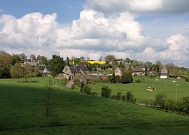
La Chapelle-Engerbold (French pronunciation: [la ʃapɛl ɑ̃ʒɛʁbo] or [la ʃapɛl ɑ̃ʒɛʁbɔld]) is a former commune in the Calvados department in the Normandy region in northwestern France. On 1 January 2016, it was merged into the new commune of Condé-en-Normandie.
The former commune is part of the area known as Suisse Normande.
Population
| Historical population | ||
|---|---|---|
| Year | Pop. | ±% |
| 1962 | 125 | — |
| 1968 | 109 | −12.8% |
| 1975 | 87 | −20.2% |
| 1982 | 93 | +6.9% |
| 1990 | 86 | −7.5% |
| 1999 | 79 | −8.1% |
| 2008 | 110 | +39.2% |
See also
 In Spanish: La Chapelle-Engerbold para niños

All content from Kiddle encyclopedia articles (including the article images and facts) can be freely used under Attribution-ShareAlike license, unless stated otherwise. Cite this article:
La Chapelle-Engerbold Facts for Kids. Kiddle Encyclopedia.


