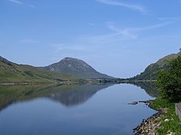
Kylemore Lough facts for kids
Quick facts for kids Kylemore Lough |
|
|---|---|
 |
|
| Location | County Galway |
| Coordinates | 53°33′37″N 9°51′16″W / 53.56028°N 9.85444°W |
| Native name | Loch na Coille Móire Error {{native name checker}}: parameter value is malformed (help) |
| Primary inflows | Kylemore River |
| Catchment area | 20.91 km2 (8.1 sq mi) |
| Basin countries | Ireland |
| Max. length | 2.4 km (1.5 mi) |
| Max. width | 0.7 km (0.4 mi) |
| Surface area | 1.32 km2 (0.51 sq mi) |
| Surface elevation | 35 m (115 ft) |
Kylemore Lough (Irish: Loch na Coille Móire) is a freshwater lake in the west of Ireland. It is located in the Connemara area of County Galway.
Geography
Kylemore Lough measures about 2 km (1.2 mi) long and 1 km (0.6 mi) wide. It is located about 20 km (12 mi) northeast of Clifden, just east of Connemara National Park. Kylemore Abbey, a major area attraction, is located on the shore of neighbouring Pollacapall Lough.
Natural history
Fish species in Kylemore Lough include salmon and brown trout. Kylemore Lough is part of The Twelve Bens/Garraun Complex Special Area of Conservation.

All content from Kiddle encyclopedia articles (including the article images and facts) can be freely used under Attribution-ShareAlike license, unless stated otherwise. Cite this article:
Kylemore Lough Facts for Kids. Kiddle Encyclopedia.

