
Koyra Upazila facts for kids
Quick facts for kids
Koyra
কয়রা
|
|
|---|---|

Koyra Upazila
Location in Bangladesh
|
|
| Country | |
| Division | Khulna Division |
| District | Khulna District |
| Area | |
| • Total | 1,775.41 km2 (685.49 sq mi) |
| Population
(1991)
|
|
| • Total | 165,473 |
| • Density | 93.2027/km2 (241.3939/sq mi) |
| Time zone | UTC+6 (BST) |
| Postal code |
9290
|
Koyra (Bengali: কয়রা) is an Upazila of Khulna District in the Division of Khulna, Bangladesh.It's the 2nd largest Upazila in Bangladesh.
Geography
Koyra is located at 22°20′30″N 89°18′00″E / 22.3417°N 89.3000°E. It has 28,061 households and a total area 1775.41 km².
Images for kids
-
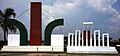
Monument and shahid minar, koyra
-

Man collecting mangrove palm in the Sundarbans in Koyra.
-
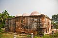
A back view of Masjidkur, an ancient mosque in Koyra discovered in the 20th century.

_-_panoramio.jpg)


All content from Kiddle encyclopedia articles (including the article images and facts) can be freely used under Attribution-ShareAlike license, unless stated otherwise. Cite this article:
Koyra Upazila Facts for Kids. Kiddle Encyclopedia.