Kingston SE facts for kids
Quick facts for kids Kingston SESouth Australia |
|||||||||||||||
|---|---|---|---|---|---|---|---|---|---|---|---|---|---|---|---|

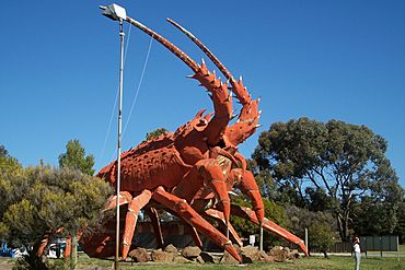
Lobster sculpture located at the entrance to the town
|
|||||||||||||||
| Established | 1861 (town) 3 December 1998 (locality) |
||||||||||||||
| Postcode(s) | 5275 | ||||||||||||||
| Time zone | ACST (UTC+9:30) | ||||||||||||||
| • Summer (DST) | ACDT (UTC+10:30) | ||||||||||||||
| Location |
|
||||||||||||||
| LGA(s) | Kingston District Council | ||||||||||||||
| State electorate(s) | MacKillop | ||||||||||||||
| Federal Division(s) | Barker | ||||||||||||||
|
|||||||||||||||
|
|||||||||||||||
| Footnotes | Locations Adjoining Localities |
||||||||||||||
Kingston SE (Kingston South East to distinguish it from Kingston on Murray), formerly Kingston, is a town in the Australian state of South Australia located in the state's south-east coastline on the shores of Lacepede Bay. It is located about 240 kilometres (150 miles) southeast of the state capital of Adelaide and 138 kilometres (86 miles) north-west of the centre of the city of Mount Gambier.
At the 2021 census, Kingston SE had a population of 1,637.
History
The town was named after Sir George Strickland Kingston, a South Australian politician, surveyor and architect. Kingston Post Office opened on 9 February 1869. The extension on its name is to distinguish Kingston in the South East (of South Australia) from another 'Kingston' in the state which is now officially named "Kingston On Murray" was added in July 1940. The present-day town of Kingston SE includes the original Kingston, as well as the towns of Port Caroline and Maria Creek.
The town was connected to Naracoorte by a 3 ft 6 in (1,067 mm) railway in 1876, providing a port for the grain and wool grown away from the coast. The rails were converted to broad gauge 5 ft 3 in (1,600 mm) in 1959. The railway closed on 28 November 1987 then was dismantled on 15 September 1991.
Media
The region was formerly serviced by two newspapers: the Kingston Weekly, the newspaper of The Kingston Traders' Association, was issued between 22 March 1946 and 30 March 1951. Later, the South-East Kingston Leader was started in Kingston, and was published from 1962 until 21 November 2001 when it was renamed Coastal Leader. It is now owned by Australian Community Media.
Today
At the 2021 census, Kingston SE had a population of 1,637.
The main industries are fishing, wine-making, sheep and cattle farming and recreation, the district having a large influx of tourists during holiday periods throughout the year.
The northern entrance to the town is dominated by the Big Lobster, named "Larry" by people in Kingston.
The town has an Australian rules football team competing in the Kowree-Naracoorte-Tatiara Football League.
Kingston SE is home to the Cape Jaffa Lighthouse, which was moved to its current location from its former location on Margaret Brock Reef, and now operates as a museum. The museum also houses a lifeboat from MS Oliva which washed ashore after two years adrift.
Climate
Kingston has a warm-summer Mediterranean climate (Csb).
| Climate data for Cape Jaffa | |||||||||||||
|---|---|---|---|---|---|---|---|---|---|---|---|---|---|
| Month | Jan | Feb | Mar | Apr | May | Jun | Jul | Aug | Sep | Oct | Nov | Dec | Year |
| Record high °C (°F) | 41.6 (106.9) |
40.8 (105.4) |
37.3 (99.1) |
33.1 (91.6) |
27.2 (81.0) |
22.4 (72.3) |
19.5 (67.1) |
23.3 (73.9) |
27.5 (81.5) |
33.1 (91.6) |
37.2 (99.0) |
40.3 (104.5) |
41.6 (106.9) |
| Mean daily maximum °C (°F) | 24.6 (76.3) |
24.6 (76.3) |
22.7 (72.9) |
19.9 (67.8) |
17.0 (62.6) |
14.7 (58.5) |
14.0 (57.2) |
14.6 (58.3) |
16.1 (61.0) |
18.5 (65.3) |
21.4 (70.5) |
22.8 (73.0) |
19.2 (66.6) |
| Mean daily minimum °C (°F) | 13.6 (56.5) |
13.6 (56.5) |
12.4 (54.3) |
10.6 (51.1) |
9.2 (48.6) |
8.0 (46.4) |
7.5 (45.5) |
7.8 (46.0) |
8.5 (47.3) |
9.1 (48.4) |
10.8 (51.4) |
12.3 (54.1) |
10.3 (50.5) |
| Record low °C (°F) | 6.5 (43.7) |
6.3 (43.3) |
5.2 (41.4) |
1.3 (34.3) |
0.0 (32.0) |
−0.7 (30.7) |
0.1 (32.2) |
0.2 (32.4) |
1.0 (33.8) |
2.6 (36.7) |
3.4 (38.1) |
4.7 (40.5) |
−0.7 (30.7) |
| Average rainfall mm (inches) | 16.6 (0.65) |
17.6 (0.69) |
22.6 (0.89) |
33.5 (1.32) |
50.6 (1.99) |
69.3 (2.73) |
81.0 (3.19) |
71.5 (2.81) |
47.9 (1.89) |
33.8 (1.33) |
26.7 (1.05) |
24.5 (0.96) |
495.6 (19.5) |
| Average rainy days (≥ 0.2mm) | 5.6 | 4.9 | 8.5 | 12.5 | 16.9 | 18.6 | 19.6 | 21.4 | 16.8 | 12.8 | 8.7 | 8.5 | 154.8 |
| Source: Bureau of Meteorology | |||||||||||||


