Khagrachari District facts for kids
Quick facts for kids
Khagrachhari
|
|
|---|---|
| Nickname(s):
The Queen of Natural Beauty/The City of Valleys
|
|
| Motto(s):
Beauty Lies in Diversity
|
|

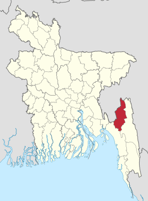
Location of Khagrachhari in Bangladesh
|
|
| Country | |
| Division | Chittagong Division |
| Area | |
| • Total | 2,749.16 km2 (1,061.46 sq mi) |
| Population
(2011 census)
|
|
| • Total | 613,917 |
| • Density | 223.3108/km2 (578.3722/sq mi) |
| Demonym(s) | Khagrasoria |
| Time zone | UTC+6 (BST) |
| • Summer (DST) | UTC+7 (BDST) |
| Postal code |
4400
|
Khagrachhari is a district in Chittagong Division, south-eastern Bangladesh and the Chittagong Hill Tracts. Khagrachhari is also known as the Mong Circle. Khagrachhari town is the hometown of the Mong Chief.
Khagrachari is a hilly area. It is bounded by the state of India on the north, Rangamati and chittagong districts on the south, Rangamati district on the east, Chittagong District and Tripura state of India on the west.
It has three rivers, namely Chengi, Feni and Maini. Chengi is the longest river in Khagrachhari. The main ethnic groups living in the district are Tripuris, Chakmas, Bengalis and Marmas.
Most of the people live on Jhum cultivation. There are archaeological heritages and relics, Rajbari of the Mong Circle and Dighi (large pond) of Dighinala (excavated by Gobindo Manikko exiled king of Tripura) are notable.
See also
 In Spanish: Khagrachari (zila) para niños

