Kerman province facts for kids
Quick facts for kids
Kerman province
Persian: استان کرمان
|
|
|---|---|
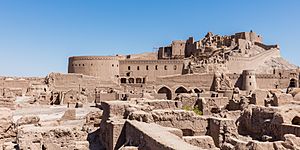
Bam Fortress (2016)
|
|
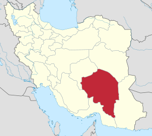
Location of Kerman province within Iran
|
|
| Country | |
| Region | Region 5 |
| Capital | Kerman |
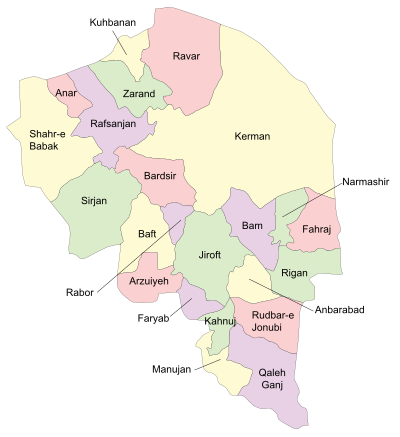
| Counties | 25 |
| Area | |
| • Total | 183,285 km2 (70,767 sq mi) |
| Elevation | 192 m (630 ft) |
| Population
(2016)
|
|
| • Total | 3,164,718 |
| • Density | 17.26665/km2 (44.72042/sq mi) |
| Time zone | UTC+03:30 (IRST) |
| Main language(s) | Persian |
| HDI (2017) | 0.778 high · 20th |
| Website | www.gov.kr.ir |
Kerman province (Persian: استان کرمان, Ostān-e Kermān) is the largest province of the 31 provinces of Iran. It is in the southeast of Iran, with its capital in the city of Kerman. In 2014 it was placed in Region 5. Mentioned in ancient times as the Achaemenid satrapy of Carmania, Kerman province has an area of 183,285 km2 (70,767 sq mi), encompassing nearly 11% of the land area of Iran.
At the time of the National Census of 2006, the population of the province was 2,584,834 in 612,996 households. The following census in 2011 counted 2,938,988 people (1,482,339 male and 1,456,649 female) in 785,747 households. Urban areas accounted for 1,684,982 people, whereas 1,242,344 lived in rural vicinities; 6,082 were non-residents. By the time of the 2016 census, the population had increased to 3,164,718 in 932,721 households. The capital city of Kerman, at a population of 537,718, comprises about 29% of the urban population of 1.85 million, being the most developed and largest city of the province.
The population of Kerman province includes the majority Fars and many Iranian ethnicities such as Lor, Kurd, Lak, Afshar-Turk, Jebal-Barezi, Zartoshti, Baluch, Larestani, Bandari, Pishdar and Ghassemlou.
Contents
Geography
The altitudes and heights of the province are the continuation of the central mountain ranges of Iran. They extend from the volcanic folds beginning in Azarbaijan and, by branching out in the central plateau of Iran, terminate in Baluchestan. These mountain ranges have brought about vast plains in the province. The Bashagard and Kuhbonan Mountains are the highest in this region and include peaks such as Toghrol, Aljerd, Palvar, Sirach, Abareq and Tahrood. Other ranges that stretch out from Yazd to Kerman and Challeh-ye-Jazmoorian include high peaks like Hazaran 4501 meters above sea level, Kuh-e Shah 4402 meters, Joupar, Bahr Aseman and Khabr mountain in Khabr National Park and others.
Most of the province is largely steppe or sandy desert, although there are some oases where dates, oranges (said to be the best in Iran), and pistachios are cultivated. In antiquity "Carmanian" wine was famed for its quality [Strabo XV.2.14 (cap. 726)]. The province is dependent on qanats (underground water channels) for its irrigation. In the central parts, Mount Hezar is the highest peak, 4501 meters above sea level.
Kerman is prone to natural disasters. A recent flood for example, unearthed the archeological ancient city of Jiroft, in the south of Kerman province. Arg-é Bam on the other hand, the world's largest adobe structure, was destroyed in an earthquake in December 2003. On February 22, 2005, a major earthquake killed hundreds of residents in the town of Zarand and several nearby villages in north Kerman.
History
According to a text from the 8th century commontly attributed to the Armenian historian Movses Khorenatsi, present-day Kerman province was situated in the southern quarter of the Sasanian Empire. The main city of the region from the Sasanian era to the 10th century was Sirjan.
Early Muslim geographers considered the area as part of the hot climatic zone and the mountainous interior as home of predatory people including the Kufečs (or Kofejān). Hamdallah Mustawfi stated that predatory beasts roamed the area which by then had undergone forestation.
In the 13th century it came under the rule of the Qutlugh-Khanids founded by ethnic Khitans, than under the Mongol empire. It was under the Timurid empire in 15th century.
Administrative divisions
| Administrative Divisions | 2006 | 2011 | 2016 |
|---|---|---|---|
| Anar County1 | — | 35,295 | 36,897 |
| Anbarabad County | 113,751 | 85,942 | 82,438 |
| Arzuiyeh County2 | — | 41,979 | 38,510 |
| Baft County | 138,847 | 75,940 | 84,103 |
| Bam County | 277,835 | 195,603 | 228,241 |
| Bardsir County | 84,543 | 73,738 | 81,983 |
| Fahraj County3 | — | 68,038 | 67,096 |
| Faryab County1 | — | 34,417 | 34,000 |
| Gonbaki County4 | — | — | — |
| Jazmurian County5 | — | — | — |
| Jiroft County | 181,300 | 277,748 | 308,858 |
| Kahnuj County | 102,269 | 86,290 | 95,848 |
| Kerman County | 654,052 | 722,484 | 738,724 |
| Kuhbanan County | 24,465 | 21,721 | 21,205 |
| Manujan County | 63,270 | 64,528 | 65,705 |
| Narmashir County3 | — | 58,229 | 54,228 |
| Qaleh Ganj County | 69,008 | 76,376 | 76,495 |
| Rabor County2 | — | 34,392 | 35,362 |
| Rafsanjan County | 291,417 | 287,921 | 311,214 |
| Ravar County | 38,539 | 40,295 | 43,198 |
| Rigan County3 | — | 66,335 | 88,410 |
| Rudbar-e Jonubi County | 86,747 | 104,421 | 105,992 |
| Shahr-e Babak County | 100,192 | 90,495 | 103,975 |
| Sirjan County | 239,455 | 267,697 | 324,103 |
| Zarand County | 119,144 | 129,104 | 138,133 |
| Total | 2,584,834 | 2,938,988 | 3,164,718 |
| 1Separated from Rafsanjan County 2Separated from Baft County 3Separated from Bam County 4Separated from Rigan County 5Separated from Rudbar-e Jonubi County |
|||
Cities
According to the 2016 census, 1,858,587 people (over 58% of the population of Kerman province) live in the following cities: Aminshahr 4,413, Anar 15,532, Anbarabad 18,185, Anduhjerd 4,041, Arzuiyeh 6,868, Baft 34,517, Baghin 10,407, Bahreman 5,265, Balvard 3,534, Bam 127,396, Baravat 22,761, Bardsir 25,152, Bezenjan 4,517, Boluk 5,304, Chatrud 5,860, Darb-e Behesht 10,670, Dashtkar 3,234, Dehaj 5,045, Dow Sari 4,130, Ekhtiarabad 9,840, Fahraj 6,876, Faryab 4,863, Golbaf 9,205, Golzar 5,445, Gonbaki 7,210, Hamashahr 3,311, Hanza 1,452, Hojedk 1,007, Jebalbarez 6,750, Jiroft 130,429, Jowzam 3,436, Jupar 3,607, Kahnuj 52,624, Kazemabad 4,060, Kerman 537,718, Khanuk 2,628, Khatunabad 5,471, Khursand 8,252, Khvajeh Shahr 2,478, Kian Shahr 4,543, Koshkuiyeh 7,644, Kuhbanan 10,761, Lalehzar 4,429, Mahan 19,423, Manujan 15,634, Mardehek 2,870, Mes-e Sarcheshmeh 5,967, Mohammadabad 20,720, Mohiabad 3,930, Najafabad 20,164, Narmashir 5,222, Negar 7,600, Nezamshahr 2,426, Nowdezh 5,562, Qaleh Ganj 13,169, Pariz 8,005, Rabor 13,263, Rafsanjan 161,909, Ravar 22,729, Rayen 10,286, Reyhan Shahr 4,580, Rudbar 14,747, Safayyeh 2,478, Shahdad 5,217, Shahr-e Babak 51,620, Sirjan 199,704, Yazdan Shahr 5,607, Zangiabad 8,568, Zarand 60,370, Zeh-e Kalut 6,835, and Zeydabad 9,112.
Most populous cities
The following sorted table, lists the most populous cities in Kerman.
| Rank | City | County | Population |
|---|---|---|---|
| 1 | Kerman | Kerman | 537,718 |
| 2 | Sirjan | Sirjan | 199,704 |
| 3 | Rafsanjan | Rafsanjan | 161,909 |
| 4 | Jiroft | Jiroft | 130,429 |
| 5 | Bam | Bam | 127,396 |
| 6 | Zarand | Zarand | 60,370 |
| 7 | Kahnuj | Kahnuj | 52,624 |
| 8 | Shahr-e Babak | Shahr-e Babak | 51,620 |
| 9 | Baft | Baft | 34,517 |
| 10 | Bardsir | Bardsir | 25,152 |
Language
The main languages of Kerman province are Persian and Garmsiri. Smaller languages include Achomi, Turkic dialects and a Median-type dialect spoken by the Jewish and Zoroastrian communities.
The Persian varieties can be considered one single Kermani accent and they are sufficiently close to Standard Persian which they share intelligibility with.
Economy
As of 1920, the province was known for the quality of its caraway. Today, Kerman is where a large portion of Iran's auto industry is based. Sirjan, a specially designated economic zone, is considered a passageway for transfer of imported commercial goods from the south (through the Persian Gulf). Arg e Jadid, is another specially designated economic zone of Iran, located in Kerman province. Furthermore, Kerman province is famous for its abundance of pistachio fields both in the city itself and surrounding ones such as Rafsanjan, Ravar and Nooq.
The Gol Gohar mine, the largest iron mine in Iran, is located in Kerman province.
Education
Colleges and universities
Kerman province contains the following universities:
- Jiroft University
- Kerman University of Medical Sciences
- Rafsanjan University of Medical Sciences
- Shahid Bahonar University of Kerman
- Sirjan University of Technology
- ValiAsr University of Rafsanjan
See also
 In Spanish: Provincia de Kermán para niños
- Kirman (Sasanian province)
- Kerman province parliamentary districts (related to the Islamic Consultative Assembly)
- List of monuments in Kerman province
- Carmania (satrapy)
- Dalfard


