Kedumba River facts for kids
Quick facts for kids Kedumba |
|
|---|---|

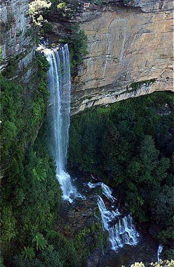
Kedumba River descending into the Jamison Valley over the Katoomba Falls, viewed from Scenic World, Katoomba, 2013.
|
|
|
Location of the Keduma River mouth in Lake Burragorang, New South Wales
|
|
| Other name(s) | Kedumba Creek (Part), Katoomba Creek (Part) |
| Country | Australia |
| State | New South Wales |
| Region | Sydney Basin (IBRA), Blue Mountains, Macarthur |
| LGAs | Blue Mountains, Wollondilly |
| Physical characteristics | |
| Main source | Blue Mountains Walford Park, Katoomba, Blue Mountains (New South Wales) 556 m (1,824 ft) 33°42′54″S 150°18′23″E / 33.71500°S 150.30639°E |
| River mouth | confluence with the Coxs River to form Lake Burragorang Policeman Point, Warragamba 120 m (390 ft) 33°51′21″S 150°20′27″E / 33.85583°S 150.34083°E |
| Length | 20 km (12 mi) |
| Basin features | |
| River system | Hawkesbury-Nepean catchment |
| Waterfalls | Katoomba Cascades, Katoomba Falls |
| National park | Blue Mountains National Park |
The Kedumba River, a perennial river that is part of the Hawkesbury-Nepean catchment, is located in the Blue Mountains and Macarthur regions of New South Wales, Australia.
Course and features
The Kedumba Creek rises on the eastern side of Walford Park, Katoomba and flows generally south over the Katoomba Cascades, Katoomba Falls, and off the Blue Mountains Range, becoming the Kedumba River below the Three Sisters flowing through the Jamison and Kedumba valleys within the Blue Mountains National Park, before reaching its confluence with the Coxs River within Lake Burragorang. The river descends 178 metres (584 ft) over its 20-kilometre (12 mi) course.

All content from Kiddle encyclopedia articles (including the article images and facts) can be freely used under Attribution-ShareAlike license, unless stated otherwise. Cite this article:
Kedumba River Facts for Kids. Kiddle Encyclopedia.


