Kasaragod district facts for kids
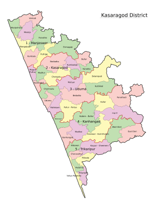
Kasaragod District is one of the 14 districts in the state of Kerala, India. Kasaragod became part of Kannur district following the reorganisation of states and formation of Kerala in November 1, 1956. Kasaragod was declared as a district on 24 May 1984.
Demographics
According to the 2011 census Kasaragod district has a population of 1,307,375, roughly equal to the nation of Mauritius or the US state of New Hampshire. This gives it a ranking of 375th in India (out of a total of 640). The district has a population density of 654 inhabitants per square kilometre (1,690/sq mi) . Its population growth rate over the decade 2001–2011 was 8.18%. Kasaragod has a sex ratio of 1079 females for every 1000 males, and a literacy rate of 89.85%.
Images for kids
-
Malik Dinar Mosque, Kasaragod, is one of the oldest mosques in India.
-
A map of Malabar District (Malayalam district) drawn by Francis Buchanan-Hamilton in 1807. Kasaragod region to the south of Payaswini/Chandragiri river of South Canara was also included in Malayalam region (just above the blue shaded region).
-
Road sign in Kasaragod town
-
Kasaragod railway station lies on Mangalore-Shoranur railway line in Palakkad railway division.
-
Panathur is an important hilly town in the district (Closer to Western Ghats)
See also
 In Spanish: Distrito de Kasaragod para niños


