Johnson County, Iowa facts for kids
Quick facts for kids
Johnson County
|
||
|---|---|---|
|
||
|
||
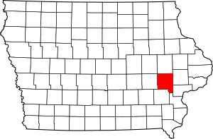
Location within the U.S. state of Iowa
|
||
 Iowa's location within the U.S. |
||
| Country | ||
| State | ||
| Founded | December 21, 1837 | |
| Named for | Richard Mentor Johnson (1837–2020) Lulu Johnson (since 2020) |
|
| Seat | Iowa City | |
| Largest city | Iowa City | |
| Area | ||
| • Total | 623 sq mi (1,610 km2) | |
| • Land | 614 sq mi (1,590 km2) | |
| • Water | 9.1 sq mi (24 km2) 1.5% | |
| Population
(2020)
|
||
| • Total | 152,854 | |
| • Estimate
(2023)
|
157,528 |
|
| • Density | 250/sq mi (100/km2) | |
| Time zone | UTC−6 (Central) | |
| • Summer (DST) | UTC−5 (CDT) | |
| Congressional district | 1st | |
Johnson County is located in the U.S. state of Iowa. As of the 2020 census, the population was 152,854, making it the fourth-most populous county in Iowa. The county seat is Iowa City, home of the University of Iowa. Johnson County is included in the Iowa City metropolitan area, which is also included in the Cedar Rapids-Iowa City Corridor Combined Statistical Area.
Contents
History
Johnson County was created on December 21, 1837 by the legislature of the Wisconsin Territory. The county was carved out of territory formerly in Dubuque County, and was not initially provided with a civil government, instead being governed by Cedar County officials. It was named for the US Vice President Richard M. Johnson.
The first courthouse in the county was a two story log cabin structure, built in 1838 in the town of Napoleon, about two miles south of the current courthouse. The building stood across from what later would become the James McCollister Farmstead on land later owned by Philip Clark.
After Iowa City was established by fiat as the new territorial capitol of Iowa, the county seat was removed there. The second Johnson County Courthouse, the first in Iowa City, was built on Lot 8 Block 8 of the County Seat Addition to Iowa City in 1842 for $3,690. This location was in the southeast corner of the intersection of Harrison and Clinton Streets. The building was intended to be 56 x 28 feet and two stories tall. The building was built by James Trimble, who had previously built the first jail.
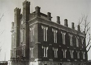
A third courthouse was built in 1857 in the courthouse square located on Clinton Street between Court and Harrison Streets. It was used until it was found to be dangerous due to cracks in the south wall in 1899. The building was apparently built of brick with stone and wood ornamentation.
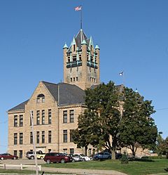
The Richardsonian Romanesque style courthouse in use today was designed by the firm of Rush, Bowman and Rush of Grand Rapids, MI. It was bid at a cost of $111,000 and built by the firm Rowson and Son of Johnson County. The cornerstone was laid in December 1899. The building's tower was based on Henry Hobson Richardson's design for the spire of Trinity Church in Boston. The building was dedicated on June 8, 1901. The currently unused jail that stands to the west of the courthouse was designed by C.L. Wundt of Burlington on behalf of the Stewart Iron Works, Cleveland, OH and bid for $14,000.
Geography
According to the U.S. Census Bureau, the county has a total area of 623 square miles (1,610 km2), of which 614 square miles (1,590 km2) is land and 9.1 square miles (24 km2) (1.5%) is water.
Major highways
 Interstate 80
 Interstate 380
 U.S. Highway 6
 U.S. Highway 218
 Iowa Highway 1
 Iowa Highway 22
 Iowa Highway 27
Adjacent counties
- Linn County (north)
- Cedar County (northeast)
- Muscatine County & Louisa County (southeast)
- Washington County (southwest)
- Iowa County (west)
- Benton County (northwest)
Demographics
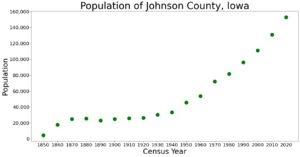
| Historical population | |||
|---|---|---|---|
| Census | Pop. | %± | |
| 1850 | 4,472 | — | |
| 1860 | 17,573 | 293.0% | |
| 1870 | 24,898 | 41.7% | |
| 1880 | 25,429 | 2.1% | |
| 1890 | 23,082 | −9.2% | |
| 1900 | 24,817 | 7.5% | |
| 1910 | 25,914 | 4.4% | |
| 1920 | 26,462 | 2.1% | |
| 1930 | 30,276 | 14.4% | |
| 1940 | 33,191 | 9.6% | |
| 1950 | 45,756 | 37.9% | |
| 1960 | 53,663 | 17.3% | |
| 1970 | 72,127 | 34.4% | |
| 1980 | 81,717 | 13.3% | |
| 1990 | 96,119 | 17.6% | |
| 2000 | 111,006 | 15.5% | |
| 2010 | 130,882 | 17.9% | |
| 2020 | 152,854 | 16.8% | |
| 2023 (est.) | 157,528 | 20.4% | |
| U.S. Decennial Census 1790–1960 1900–1990 1990–2000 2010–2019 |
|||
2020 census
The 2020 census recorded a population of 152,854 in the county, with a population density of 245.8946/sq mi (94.9404/km2). 93.62% of the population reported being of one race. 69.93% were non-Hispanic White, 8.40% were Black, 6.67% were Hispanic, 0.21% were Native American, 5.63% were Asian, 0.03% were Native Hawaiian or Pacific Islander and 9.13% were some other race or more than one race. There were 65,916 housing units, of which 61,335 were occupied.
2010 census
The 2010 census recorded a population of 130,882 in the county, with a population density of 212.9964/sq mi (82.2384/km2). There were 55,967 housing units, of which 52,715 were occupied.
Communities
Cities
Census-designated place
Other unincorporated communities
Ghost towns
Townships
- Big Grove Township
- Cedar Township
- Clear Creek Township
- East Lucas Township
- Fremont Township
- Graham Township
- Hardin Township
- Jefferson Township
- Liberty Township
- Lincoln Township
- Madison Township
- Monroe Township
- Newport Township
- Oxford Township
- Penn Township
- Pleasant Valley Township
- Scott Township
- Sharon Township
- Union Township
- Washington Township
Population ranking
The population ranking of the following table is based on the 2010 census of Johnson County.
† county seat
| Rank | City/Town/etc. | Municipal type | Population (2010 Census) |
|---|---|---|---|
| 1 | † Iowa City | City | 67,862 |
| 2 | Coralville | City | 18,907 |
| 3 | North Liberty | City | 13,374 |
| 4 | West Branch (mostly in Cedar County) | City | 2,322 |
| 5 | Solon | City | 2,037 |
| 6 | Tiffin | City | 1,947 |
| 7 | Lone Tree | City | 1,300 |
| 8 | University Heights | City | 1,051 |
| 9 | Swisher | City | 879 |
| 10 | Oxford | City | 807 |
| 11 | Hills | City | 703 |
| 12 | Shueyville | City | 577 |
| 13 | Frytown | CDP | 165 |
See also
 In Spanish: Condado de Johnson (Iowa) para niños


