Jimmy Carter Regional Airport facts for kids
Quick facts for kids
Jimmy Carter Regional Airport
Souther Field |
|||||||||||||||
|---|---|---|---|---|---|---|---|---|---|---|---|---|---|---|---|

2006 USGS airphoto
|
|||||||||||||||
| Summary | |||||||||||||||
| Airport type | Public | ||||||||||||||
| Owner | Sumter County and Airport Authority | ||||||||||||||
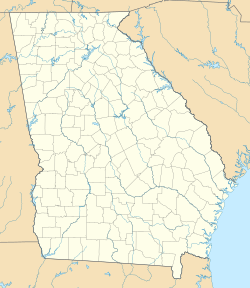
| Location | Sumter County, near Americus, Georgia | ||||||||||||||
| Elevation AMSL | 471 ft / 144 m | ||||||||||||||
| Coordinates | 32°06′38.8770″N 084°11′19.85″W / 32.110799167°N 84.1888472°W | ||||||||||||||
| Map | |||||||||||||||
| Runway | |||||||||||||||
|
|||||||||||||||
| Statistics (2006) | |||||||||||||||
|
|||||||||||||||
|
Source: Federal Aviation Administration
|
|||||||||||||||
Jimmy Carter Regional Airport (ICAO: KACJ, FAA LID: ACJ) previously Souther Field is a public airport located four miles (6 km) northeast of the central business district of Americus, in Sumter County, Georgia, United States. It owned by the Sumter County and Airport Authority.

All content from Kiddle encyclopedia articles (including the article images and facts) can be freely used under Attribution-ShareAlike license, unless stated otherwise. Cite this article:
Jimmy Carter Regional Airport Facts for Kids. Kiddle Encyclopedia.

