Jiguaní facts for kids
Quick facts for kids
Jiguaní
|
|
|---|---|
 |
|

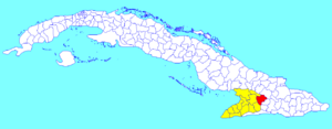
Jiguaní municipality (red) within
Granma Province (yellow) and Cuba |
|
| Country | Cuba |
| Province | Granma |
| Established | 1701 |
| Area | |
| • Total | 646 km2 (249 sq mi) |
| Elevation | 125 m (410 ft) |
| Population
(2022)
|
|
| • Total | 58,982 |
| • Density | 91.30/km2 (236.47/sq mi) |
| Time zone | UTC-5 (EST) |
| Area code(s) | +53-23 |
| Website | https://www.jiguani.gob.cu/es/ |
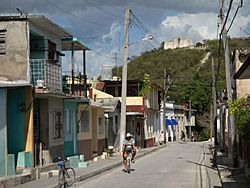
Jiguaní (Spanish pronunciation: [xiɣwaˈni]) is a town and municipality in the Granma Province of Cuba. It is located 25 kilometres (16 mi) east of Bayamo, the provincial capital.
Overview
The municipality is divided into the barrios of Babiney, Baire, Bijagual, La Villa, Los Negros, Maffo, Rihito and Santa Rita.
The name "Jiguaní" is of Taíno origin, and means "height of the river". The town of Jiguaní was a stronghold and a starting point in the independence war of 1895.
Demographics
In 2022, the municipality of Jiguaní had a population of 58,982. With a total area of 646 km2 (249 sq mi), it has a population density of 91/km2 (240/sq mi).
See also
 In Spanish: Jiguaní para niños

All content from Kiddle encyclopedia articles (including the article images and facts) can be freely used under Attribution-ShareAlike license, unless stated otherwise. Cite this article:
Jiguaní Facts for Kids. Kiddle Encyclopedia.
