Jemez Lineament facts for kids
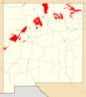
The Jemez Lineament is a chain of late Cenozoic volcanic fields, 600 km long, reaching from the Springerville and White Mountains volcanic fields in East-Central Arizona to the Raton-Clayton volcanic field in Northeastern New Mexico.
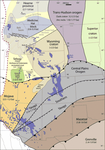
The lineament was long interpreted as a hotspot trace (Raton hotspot) due to its resemblance in length and direction to the Yellowstone hot spot trace, but there is no systematic progression in age along the trace and it is now interpreted as a hydrous subduction zone scar. This formed about 1.7 billion years ago, when oceanic crust was subducting under what was then the southern edge of North America. The arrival of a large island arc in the subduction zone shifted subduction further south, leaving remnants of oceanic crust at the top of the Earth's mantle along the former subduction zone. These are rich in hydrous minerals that lower the melting temperature of the rock containing them. This hydrous subduction scar now separates basement rock of the Yavapai-Mazatzal transition zone from the Mazaztl Province proper.
Volcano fields
The Jemez Lineament consists of the San Carlos volcanic field, Springerville volcanic field, Red Hill volcanic field, Zuni-Bandera volcanic field, Mount Taylor volcanic field, Jemez volcanic field and possibly the Ocate volcanic field, Raton-Clayton volcanic field, and Mesa de Maya. These are all young (Cenozoic) volcanic fields, showing some progression in age from southeast to northwest (across the Lineament) but no systematic progression in age along the Lineament.
The total surface area of volcanic products of the Jemez Lineament volcanic fields is 23,870 square kilometers (9,220 sq mi). The total erupted volume is about 3,300 cubic kilometers (790 cu mi). The Jemez volcanic field, located at the intersection of the Rio Grande Rift with the lineament, has produced three times the volume of eruption as the other fields in the lineament combined.
The trace of the lineament changes slightly across the Rio Grande rift. To the west of the rift, the lineament follows the southeastern margin of the Colorado Plateau. East of the rift, the lineament cuts acros the High Plains.
Origin
The fields within the lineament vary considerably in geometry perpendicular to the trend of the lineament, showing that the lineament does not consist of a single fault or other structure. It is interpreted instead as a hydrous subduction zone scar marking the southern boundary of the pre-1.70 GYa Yavapai basement. Seismic imaging shows both north- and south-dipping reflections that converge at the crust-mantle boundary. There is also a Pb-isotopic boundary coincident with the Lineament. Geophysical studies have identified a low-velocity upper mantle zone coincident with the lineament. The lineament is a zone of persistent crustal weakness.


