Ittenthal facts for kids
Quick facts for kids
Ittenthal
|
||
|---|---|---|
 |
||
|
||
| Country | Switzerland | |
| Canton | Aargau | |
| District | Laufenburg | |
| Area | ||
| • Total | 3.89 km2 (1.50 sq mi) | |
| Elevation | 404 m (1,325 ft) | |
| Population
(December 2006)
|
||
| • Total | 201 | |
| • Density | 51.67/km2 (133.8/sq mi) | |
| Postal code |
5083
|
|
| Surrounded by | Frick, Hornussen, Kaisten, Sulz | |
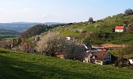
Ittenthal was a municipality in the district of Laufenburg in the canton of Aargau in Switzerland. On 1 January 2010, Ittenthal merged into the municipality of Kaisten.
The historical population is given in the following table:
| year | population |
|---|---|
| 1803 | 171 |
| 1850 | 265 |
| 1900 | 217 |
| 1950 | 221 |
| 2000 | 222 |

All content from Kiddle encyclopedia articles (including the article images and facts) can be freely used under Attribution-ShareAlike license, unless stated otherwise. Cite this article:
Ittenthal Facts for Kids. Kiddle Encyclopedia.


