Ironside, Oregon facts for kids
Quick facts for kids
Ironside, Oregon
|
|
|---|---|

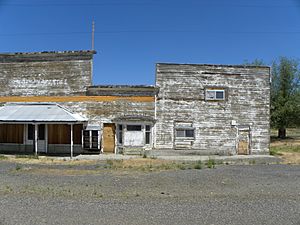
Abandoned building in Ironside
|
|
| Country | United States |
| State | Oregon |
| County | Malheur |
| Elevation | 3,783 ft (1,153 m) |
| Time zone | UTC−07:00 (Mountain (MST)) |
| • Summer (DST) | UTC−06:00 (MST) |
| ZIP Code |
97908
|
| Area code(s) | 541 |
| GNIS feature ID | 1136412 |
| Coordinates and elevation from Geographic Names Information System | |
Ironside is an unincorporated community in Malheur County, Oregon, United States. The community is 46 miles (74 km) northwest of Vale along U.S. Route 26. Ironside has a post office with ZIP Code 97908.
Climate
According to the Köppen Climate Classification system, Ironside has a semi-arid climate, abbreviated "BSk" on climate maps.

All content from Kiddle encyclopedia articles (including the article images and facts) can be freely used under Attribution-ShareAlike license, unless stated otherwise. Cite this article:
Ironside, Oregon Facts for Kids. Kiddle Encyclopedia.


