Ionian Sea facts for kids
Quick facts for kids Ionian Sea |
|
|---|---|

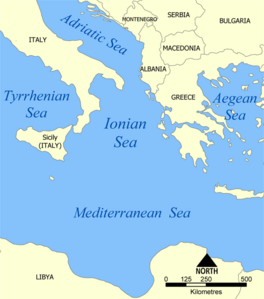
Map of the Ionian Sea
|
|
| Location | Europe |
| Coordinates | 38°N 19°E / 38°N 19°E |
| Type | Sea |
| Primary outflows | Mediterranean Sea |
| Basin countries | Albania, Italy, Greece |
| Islands | List of islands in the Ionian Sea |
| Settlements | Igoumenitsa, Parga, Preveza, Astakos, Patras, Kerkyra, Lefkada, Argostoli, Zakynthos, Kyparissia, Pylos, Kalamata, Himarë, Saranda, Syracuse, Catania, Taormina, Messina, Taranto |
The Ionian Sea is an arm of the Mediterranean Sea, south of the Adriatic Sea. It is bordered by southern Italy like Calabria, Sicily and the Salento peninsula to the west, and by southwestern Albania, like Saranda and Himara, and a large number of Greek islands, like Corfu, Zante, Kephalonia, Ithaka, and Lefkas to the east. The islands are most of the time referred to as the Ionian Islands, and other islands like the Strophades, Sphagia, Schiza, Sapientza and Kythira. The sea is one of the most seismic areas in the world.
There are ferry routes between Patras, Greece and Brindisi and Ancona, Italy, that cross the east and north of the Ionian Sea, and from Piraeus westward.
Images for kids
-
Gjipe in the south of Albania where the Adriatic Sea meets the Ionian Sea
-
The Ionian Sea, view from the island Lefkada, Greece
See also
 In Spanish: Mar Jónico para niños


