
Inver Grove Heights, Minnesota facts for kids
Quick facts for kids
Inver Grove Heights, Minnesota
|
|
|---|---|
 |
|
| Nickname(s):
Inver Grove
|
|

Location of Inver Grove Heights, Minnesota
|
|
| Country | United States |
| State | Minnesota |
| County | Dakota |
| Established | 1852 |
| Incorporated | March 9, 1965 |
| Government | |
| • Type | Weak Mayor–Council |
| Area | |
| • Total | 30.22 sq mi (78.27 km2) |
| • Land | 27.85 sq mi (72.14 km2) |
| • Water | 2.37 sq mi (6.13 km2) |
| Elevation | 879 ft (268 m) |
| Population
(2020)
|
|
| • Total | 35,801 |
| • Estimate
(2022)
|
35,701 |
| • Density | 1,285.31/sq mi (496.25/km2) |
| Time zone | UTC-6 (Central) |
| • Summer (DST) | UTC-5 (CDT) |
| ZIP codes |
55076, 55077
|
| Area code(s) | 651 |
| FIPS code | 27-31076 |
| GNIS feature ID | 0645437 |
Inver Grove Heights is a city in Dakota County, Minnesota, United States. The population was 35,801 at the 2020 census. The city was formed on March 9, 1965, with the merger of the village of Inver Grove and Inver Grove Township.
It is one of 186 cities and townships in the seven-county Minneapolis-Saint Paul metropolitan area. Inver Grove Heights is 9 miles (14 km) southeast of Saint Paul; nearby communities are South St. Paul, West St. Paul, Sunfish Lake, Eagan, Newport, and Saint Paul Park (the last two across the Mississippi River).
Contents
History
.jpg)
After the signing of the Treaty of Traverse des Sioux in 1851, settlers from Ireland and Germany quickly staked claims in the rolling countryside west of the Mississippi River. Those of Irish descent farmed the eastern part of the community, while Germans cleared the wooded land to the west for their farms. French and English settlers built their homes along the river. The township of Inver Grove Heights was named after the Irish fishing village of Inver and the German town of Grove. Records show that 240 farms, four churches, and four school districts were founded by 1880. On March 9, 1965, the village of Inver Grove and Inver Grove Township merged to form Inver Grove Heights.
Historic sites in Inver Grove Heights include:
- Chief Medicine Bottle's Village: formed in 1836, became Pine Bend village and post office
- Mendota-Wabasha Road: a military road laid out by John S. Potter in 1853. Rich Valley Road now follows the old military road.
- District 7 School: Dakota County's first public school, established in 1854
- Salem United Methodist Church, organized in 1854
- Old Emanuel Lutheran Church, site of first log church in 1854; services and church school were in German
- Church of St. Patrick: Catholic church parish established on January 9, 1856
- Salem Evangelical Church: First congregation in Minnesota of the Evangelical Association of North America was organized here on March 2, 1857
- Josiah Burwell's House: where Inver Grove Township was first organized in 1858, at Rich Valley Road and 102nd Street
- Reuben Freeman House of eight gables: built in 1876 to one-up the House of Seven Gables
- Inver Grove Town Hall: first town hall building, built in 1878
- Inver Grove Village railway depot: built in 1886
- Rock Island Swing Bridge: Built in 1894, the double-decker swing bridge spanned the Mississippi River between Inver Grove Heights and St. Paul Park. Closed to rail traffic in 1980 and to road traffic in 1999, it opened as Swing Bridge park in 2011.
- Duke's Restaurant: built in 1906 as Pierkarski's butcher shop; restaurant offered food to railway workers; later became Jersey's Bar
- B-52 Crash Site: on September 16, 1958, a U.S. Air force B-52D bomber crashed while on a Cold War training mission originating from Loring Air Force Base, Limestone, Maine. Seven crewmen gave their lives for their country; marker on Broderick near West Loop Court
Geography
According to the United States Census Bureau, the city has an area of 30.12 square miles (78.01 km2), of which 27.76 square miles (71.90 km2) is land and 2.36 square miles (6.11 km2) is water.
Interstate Highway 494 (a beltway bypass of Minneapolis–Saint Paul), U.S. Highway 52, Minnesota Highway 55, and Minnesota Highway 3 are four of Inver Grove Heights's main routes. 80th Street East (numbered from downtown Saint Paul) crosses the city in an east–west direction.
In 2022, a meteoric impact crater was identified in the Pine Bend Bluffs Scientific and Natural Area in southern Inver Grove Heights. It has been informally named the "Pine Bend impact" and has been dated to 500 million years ago. It has a diameter of about four kilometers.
Demographics
| Historical population | |||
|---|---|---|---|
| Census | Pop. | %± | |
| 1860 | 646 | — | |
| 1870 | 971 | 50.3% | |
| 1880 | 791 | −18.5% | |
| 1890 | 1,211 | 53.1% | |
| 1900 | 1,402 | 15.8% | |
| 1910 | 1,384 | −1.3% | |
| 1920 | 1,573 | 13.7% | |
| 1930 | 1,617 | 2.8% | |
| 1940 | 1,887 | 16.7% | |
| 1950 | 2,419 | 28.2% | |
| 1960 | 6,266 | 159.0% | |
| 1970 | 12,148 | 93.9% | |
| 1980 | 17,171 | 41.3% | |
| 1990 | 22,477 | 30.9% | |
| 2000 | 29,751 | 32.4% | |
| 2010 | 33,880 | 13.9% | |
| 2020 | 35,801 | 5.7% | |
| 2022 (est.) | 35,701 | 5.4% | |
| U.S. Decennial Census 2020 Census Note: Inver Grove and Inver Grove Township were merged in 1965 to form Inver Grove Heights. |
|||
2010 census
As of the census of 2010, there were 33,880 people, 13,476 households, and 9,036 families living in the city. The population density was 1,220.5 inhabitants per square mile (471.2/km2). There were 14,062 housing units at an average density of 506.6 per square mile (195.6/km2). The racial makeup of the city was 85.7% White, 3.8% African American, 0.4% Native American, 3.4% Asian, 0.1% Pacific Islander, 3.5% from other races, and 3.1% from two or more races. Hispanic or Latino of any race were 8.9% of the population.
There were 13,476 households, of which 32.9% had children under the age of 18 living with them, 51.4% were married couples living together, 11.4% had a female householder with no husband present, 4.3% had a male householder with no wife present, and 32.9% were non-families. 26.2% of all households were made up of individuals, and 8.8% had someone living alone who was 65 years of age or older. The average household size was 2.50 and the average family size was 3.04.
The median age in the city was 38.4 years. 24.5% of residents were under the age of 18; 8.5% were between the ages of 18 and 24; 26.3% were from 25 to 44; 29.1% were from 45 to 64; and 11.8% were 65 years of age or older. The gender makeup of the city was 48.0% male and 52.0% female.
Economy
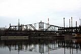
In 2007, the Metropolitan Council estimated the employment in Inver Grove Heights to be 11,158. The city hosts the headquarters of CHS, Inc., an agricultural cooperative ranked 12th in the 2007 ICA Global 300 list of mutuals and cooperatives, and 145th on the Fortune 500 list of U.S. corporations. Pine Bend Refinery, the largest oil refinery in Minnesota and fourteenth largest in the U.S., straddles the border with Rosemount. It is operated by Flint Hills Resources.
Inver Grove Heights is also the home of Gertens Greenhouses, one of the largest garden center locations in the United States.
Top employers
According to Inver Grove Heights's 2021 Comprehensive Annual Financial Report, the largest employers in the city are:
| # | Employer | # of Employees |
|---|---|---|
| 1 | Cenex / CHS Cooperatives | 1,600 |
| 2 | ISD 199 (Inver Grove Heights Community Schools) | 668 |
| 3 | Gertens | 435 |
| 4 | City of Inver Grove Heights | 421 |
| 5 | Travel Tags | 350 |
| 6 | Inver Hills Community College | 337 |
| 7 | Total Construction and Equipment | 250 |
| 8 | Walmart | 210 |
| 9 | Woodlyn Heights Senior Living | 200 |
| 10 | Cub Foods | 160 |
Education
The Inver Grove Heights Community Schools district or Independent School District 199 operates five schools in the city:
- Simley High School
- Inver Grove Heights Middle School
- Hilltop Elementary School
- Pine Bend Elementary School
- Salem Hills Elementary School
There is one private school for preschool through eighth grade in Inver Grove Heights: Berea Lutheran Church.
The western part of the city is served by Independent School District 196, with students attending Dakota Hills Middle School, Rosemount Middle School, Eagan High School, and Rosemount High School.
Inver Grove Heights is also home to Inver Hills Community College.
Sports and recreation
Facilities include Inver Wood Golf Course and Arbor Pointe Golf Club. There is also an 18-hole disc golf course called North Valley. The city also has a public community center with a waterpark, two sheets of ice and a full gym shared with the National Guard.
Gallery of images
-

B-52 Crash Site memorial with Inver Grove Heights water tower in the background
-

Plaque commemorating those who died in the B-52 crash
-
Rock Island Swing Bridge in 2008
-

Rock Island Swing Bridge Park
-

Salem Evangelical Church
-

Former Duke's Restaurant location, now Jersey's Bar and Grill
-

Bike Trail in Inver Grove Heights
-
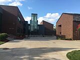
Inver Hills Fine Arts Building


.jpg)

See also
 In Spanish: Inver Grove Heights (Minnesota) para niños
