Interstate 12 facts for kids
Quick facts for kids
Interstate 12 |
||||
|---|---|---|---|---|
| Republic of West Florida Parkway | ||||
|
I-12 highlighted in red
|
||||
| Route information | ||||
| Maintained by Louisiana DOTD | ||||
| Length | 86.653 mi (139.454 km) | |||
| Existed | 1967–present | |||
| Major junctions | ||||
| West end | ||||
|
||||
| East end | ||||
| Location | ||||
| Parishes: | East Baton Rouge, Livingston, Tangipahoa, St. Tammany | |||
| Highway system | ||||
| Main route of the Interstate Highway System Main • Auxiliary • Business Highways in Louisiana
|
||||
Interstate 12 is a 85.59 miles (137.74 km) long Interstate Highway in Louisiana, connecting Interstate 10 at each end. It goes from Baton Rouge to Slidell.
Notes
Images for kids
-
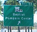
I-12's eastbound exit to LA 1249, which leads to the communities of Baptist and Pumpkin Center
-
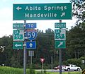
At the bottom of I-12's eastbound ramp to LA 59, travelers also find a shield for the unrelated I-59, some 20 miles (32 km) farther east
See also
 In Spanish: Interestatal 12 para niños

All content from Kiddle encyclopedia articles (including the article images and facts) can be freely used under Attribution-ShareAlike license, unless stated otherwise. Cite this article:
Interstate 12 Facts for Kids. Kiddle Encyclopedia.


