Indian Creek (Middle Island Creek tributary) facts for kids
Quick facts for kids Indian Creek |
|
|---|---|

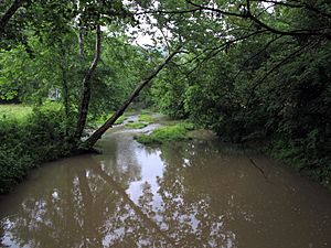
Indian Creek in Big Moses
|
|

A map of Indian Creek and its watershed
|
|
| Country | United States |
| State | West Virginia |
| County | Tyler |
| Physical characteristics | |
| Main source | near Dale 1,058 ft (322 m) 39°26′54″N 80°37′36″W / 39.4484168°N 80.6267645°W |
| River mouth | Middle Island Creek south of Blue 686 ft (209 m) 39°26′39″N 80°49′24″W / 39.4442467°N 80.8234385°W |
| Length | 14.8 mi (23.8 km) |
| Basin features | |
| Basin size | 32.3 sq mi (84 km2) |
| Hydrologic Unit Code | 050302010501 (USGS) |
Indian Creek is a tributary of Middle Island Creek, 14.8 miles (23.8 km) long, in northern West Virginia in the United States. Via Middle Island Creek and the Ohio River, it is part of the watershed of the Mississippi River, draining an area of 32.3 square miles (84 km2) in a rural region on the unglaciated portion of the Allegheny Plateau.
Indian Creek's course is entirely in eastern Tyler County. It rises near the common boundary of Tyler, Wetzel, and Doddridge counties and flows generally westward, through the unincorporated communities of Dale, Stringtown, Braden, Booher, and Big Moses. It flows into Middle Island Creek from the east, a short distance south of the community of Blue.

All content from Kiddle encyclopedia articles (including the article images and facts) can be freely used under Attribution-ShareAlike license, unless stated otherwise. Cite this article:
Indian Creek (Middle Island Creek tributary) Facts for Kids. Kiddle Encyclopedia.
