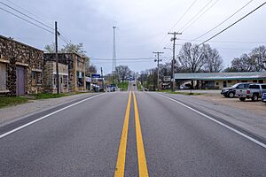
Imboden, Arkansas facts for kids
Quick facts for kids
Imboden, Arkansas
|
|
|---|---|
 |
|

Location in Lawrence County, Arkansas
|
|
| Country | United States |
| State | Arkansas |
| County | Lawrence |
| Area | |
| • Total | 1.27 sq mi (3.30 km2) |
| • Land | 1.27 sq mi (3.30 km2) |
| • Water | 0.00 sq mi (0.00 km2) |
| Elevation | 315 ft (96 m) |
| Population
(2020)
|
|
| • Total | 640 |
| • Density | 502.75/sq mi (194.16/km2) |
| Time zone | UTC-6 (Central (CST)) |
| • Summer (DST) | UTC-5 (CDT) |
| ZIP code |
72434
|
| Area code(s) | 870 |
| FIPS code | 05-34150 |
| GNIS feature ID | 0057965 |
Imboden is a city in Lawrence County, Arkansas, United States. The population was 677 at the 2010 census. It is named after a family of settlers.
Contents
History
The community was first settled around 1828 and was incorporated in 1887.
In 1912, Imboden elected Joe Sullivan as the youngest elected mayor in the United States of that period. He was 21 years old and paralyzed, so relied on a goat-driven cart. He left the town in 1914 to pursue further education.
Imboden has two public schools. Sloan-Hendrix School was established in 1899 as Sloan-Hendrix Academy, a private school affiliated with Hendrix College in Conway. It later became a public school. Imboden Area Charter School, an open-enrollment public charter school, opened in 2002.
Geography
Imboden is located in northwestern Lawrence County at 36°12′6″N 91°10′48″W / 36.20167°N 91.18000°W (36.201766, -91.179899). It is on the south side of the Spring River, a southeast-flowing tributary of the Black River. In October 2008 a modern boat launch was opened with a 20-by-210-foot (6.1 by 64.0 m) parking area. To the north of Imboden, across the Spring River, is Randolph County.
According to the United States Census Bureau, the town has a total area of 0.97 square miles (2.5 km2), all land.
List of highways


 US 62/US 63/US 412 run through the center of Imboden. The three highways leave to the west on West 3rd Street, leading 21 miles (34 km) northwest to Hardy. Highway 62 splits off to the northeast in the center of Imboden, crossing the Spring River and leading northeast 15 miles (24 km) to Pocahontas. Highways 63 and 412 leave to the southeast on East 3rd Street, leading 9 miles (14 km) to Black Rock.
 Arkansas Highway 115 leads southwest from Imboden 12 miles (19 km) to Smithville.
Demographics
| Historical population | |||
|---|---|---|---|
| Census | Pop. | %± | |
| 1890 | 157 | — | |
| 1900 | 411 | 161.8% | |
| 1910 | 600 | 46.0% | |
| 1920 | 630 | 5.0% | |
| 1930 | 564 | −10.5% | |
| 1940 | 525 | −6.9% | |
| 1950 | 447 | −14.9% | |
| 1960 | 400 | −10.5% | |
| 1970 | 496 | 24.0% | |
| 1980 | 661 | 33.3% | |
| 1990 | 616 | −6.8% | |
| 2000 | 684 | 11.0% | |
| 2010 | 677 | −1.0% | |
| 2020 | 640 | −5.5% | |
| U.S. Decennial Census | |||
2020 census
| Race | Number | Percentage |
|---|---|---|
| White (non-Hispanic) | 580 | 90.63% |
| Black or African American (non-Hispanic) | 4 | 0.63% |
| Native American | 2 | 0.31% |
| Asian | 1 | 0.16% |
| Other/Mixed | 30 | 4.69% |
| Hispanic or Latino | 23 | 3.59% |
As of the 2020 United States census, there were 640 people, 294 households, and 203 families residing in the town.
Education
Public education is provided by:
- Sloan–Hendrix School District, which leads to graduation from Sloan–Hendrix High School.
- Imboden Area Charter School, an open-enrollment school for kindergarten through eighth grade.
The Imboden Disaster Facility is currently being constructed in town. This facility is part of the Regional Center for Disaster Preparedness Education - Arkansas State University.
Attractions and recreation
- Lawrence County Fair and Rodeo - located on the Sloan-Hendrix Campus
- Annual Lawrence County Fair Auto Show - located in Imboden City Park
- Annual July 4 fireworks show - located near Sloan-Hendrix Campus
- Annual Freedom in the Park Celebration - located in Imboden City Park
- Annual Christmas Parade
See also
 In Spanish: Imboden para niños

