
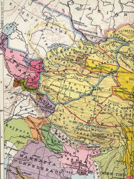
Image: Zunghar Khanate at 1760

Size of this preview: 452 × 600 pixels. Other resolutions: 181 × 240 pixels | 495 × 657 pixels.
Original image (495 × 657 pixels, file size: 122 KB, MIME type: image/jpeg)
Description: Old map of Northern India / Tibet /Xinjiang ca. 1760, showing Dzungars. Drawn in 1935 by Albert Herrmann.
Title: Zunghar Khanate at 1760
Credit: Transferred from en.wikipedia to Commons by Podzemnik using CommonsHelper.
Author: Part of the map of Albert Herrmann, published by Georg Westermann in 1935 (see complete version below) The original uploader was Enerelt at English Wikipedia. ("I fixed the pic myself")
Usage Terms: Creative Commons Attribution-Share Alike 3.0
License: CC-BY-SA-3.0
License Link: http://creativecommons.org/licenses/by-sa/3.0/
Attribution Required?: Yes
Image usage
The following image is a duplicate of this image (more details):
The following page links to this image:

All content from Kiddle encyclopedia articles (including the article images and facts) can be freely used under Attribution-ShareAlike license, unless stated otherwise.