
Image: WilmingtonOilField

Size of this preview: 776 × 600 pixels. Other resolutions: 311 × 240 pixels | 3,300 × 2,550 pixels.
Original image (3,300 × 2,550 pixels, file size: 496 KB, MIME type: image/jpeg)
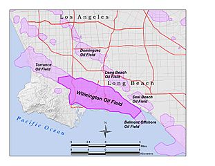
Description: Wilmington Oil Field within the Los Angeles Basin, California, U.S. All data shown on this map is in the public domain. Created by User:Antandrus using ArcGIS 9.2; data sources include US census TIGER data (2000), USGS national elevation dataset, and California Department of Natural Resources file of oil field boundaries.
Title: WilmingtonOilField
Credit: Transferred from en.wikipedia to Commons by Quadell using CommonsHelper.
Author: Antandrus at English Wikipedia
Usage Terms: Creative Commons Attribution-Share Alike 3.0
License: CC BY-SA 3.0
License Link: http://creativecommons.org/licenses/by-sa/3.0
Attribution Required?: Yes
Image usage
The following page links to this image:

All content from Kiddle encyclopedia articles (including the article images and facts) can be freely used under Attribution-ShareAlike license, unless stated otherwise.