
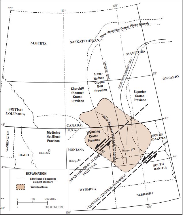
Image: Williston Basin tectonic map
Size of this preview: 509 × 600 pixels. Other resolutions: 204 × 240 pixels | 635 × 748 pixels.
Original image (635 × 748 pixels, file size: 83 KB, MIME type: image/jpeg)
Description: Williston Basin tectonic map
Title: Williston Basin tectonic map
Credit: U.S. Geological Survey Williston Basin Province Assessment Team, 2011, Assessment of undiscovered oil and gas resources of the Williston Basin Province of North Dakota, Montana, and South Dakota, 2010 (ver. 1.1, November 2013): U.S. Geological Survey Digital Data Series 69–W, 7 chaps., 1 CD-ROM, https://pubs.usgs.gov/dds/dds-069/dds-069-w/.
Author: Lawrence O. Anna, Richard Pollastro, Stephanie B. Gaswirth, Richard M. Pollastro, Laura N.R. Roberts, and Troy A. Cook
Usage Terms: Public domain
License: Public domain
Attribution Required?: No
Image usage
The following page links to this image:

All content from Kiddle encyclopedia articles (including the article images and facts) can be freely used under Attribution-ShareAlike license, unless stated otherwise.