
Image: WhakarewarewaAerial

Size of this preview: 800 × 533 pixels. Other resolutions: 320 × 213 pixels | 1,536 × 1,024 pixels.
Original image (1,536 × 1,024 pixels, file size: 648 KB, MIME type: image/jpeg)
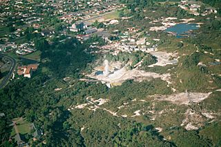
Description: Aerial view of Whakarewarewa, Rotorua, New Zealand. Pohutu Geyser is erupting in the center, the Maori Arts & Crafts Institute (which controls access to the geothermal area) is in the bottom left; and the outskirts of Rotorua are in the top left. Taken during a seaplane ride out of Rotorua.
Title: WhakarewarewaAerial
Credit: Own work
Author: Carl Lindberg
Permission: Creative Commons Attribution
Usage Terms: Creative Commons Attribution 2.5
License: CC BY 2.5
License Link: https://creativecommons.org/licenses/by/2.5
Attribution Required?: Yes
Image usage
The following 2 pages link to this image:

All content from Kiddle encyclopedia articles (including the article images and facts) can be freely used under Attribution-ShareAlike license, unless stated otherwise.