
Image: Waterview Connection Indicative Map

Size of this preview: 800 × 545 pixels. Other resolutions: 320 × 218 pixels | 880 × 600 pixels.
Original image (880 × 600 pixels, file size: 429 KB, MIME type: image/jpeg)
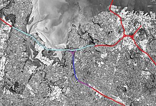
Description: Indicative view of the Auckland Motorway network, showing works of the Waterview Connection in relation to other parts of the network. Auckland, New Zealand. Red - existing network, not affected by Waterview works. Light blue - existing network, added traffic lanes. Purple - new surface section of Waterview works. Dark blue - tunnelled section of Waterview works.
Title: Waterview Connection Indicative Map
Credit: Self-photographed
Author: Ingolfson
Usage Terms: Public domain
License: Public domain
Attribution Required?: No
Image usage
The following page links to this image:

All content from Kiddle encyclopedia articles (including the article images and facts) can be freely used under Attribution-ShareAlike license, unless stated otherwise.