
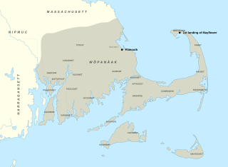
Image: Wôpanâak Nation c 1620-01

Size of this PNG preview of this SVG file: 512 × 374 pixels. Other resolution: 320 × 234 pixels.
Original image (SVG file, nominally 512 × 374 pixels, file size: 79 KB)
Description: Map of Wôpanâak bands circa 1620 This file was derived from: USA Massachusetts location map.svg Sources: National Geographic, Wampanoag Territory[1][2] Map of Wampanoag Country in the 1600s [3]
Title: Wôpanâak Nation c 1620-01
Credit: Own work
Author: Noahedits
Usage Terms: Creative Commons Attribution-Share Alike 4.0
License: CC BY-SA 4.0
License Link: https://creativecommons.org/licenses/by-sa/4.0
Attribution Required?: Yes
Image usage
The following 3 pages link to this image:

All content from Kiddle encyclopedia articles (including the article images and facts) can be freely used under Attribution-ShareAlike license, unless stated otherwise.