
Image: Usgs map mercator

Size of this PNG preview of this SVG file: 413 × 181 pixels. Other resolution: 320 × 140 pixels.
Original image (SVG file, nominally 413 × 181 pixels, file size: 525 KB)
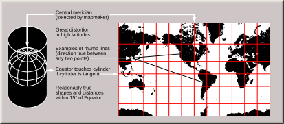
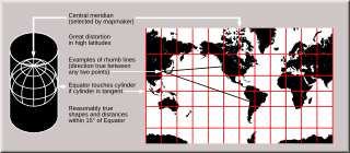
Description: Condensed explanation of Mercator-projection maps, converted to SVG format from larger USGS file of GIF format. See enlarged view below, using a wikitable to expand beyond original size.
Title: Usgs map mercator
Credit: derivative from USGS image file, URL: http://erg.usgs.gov/isb/pubs/MapProjections/graphics/mercator.gif
Author: derived from US Government USGS
Usage Terms: Public domain
License: Public domain
Attribution Required?: No
Image usage
The following page links to this image:

All content from Kiddle encyclopedia articles (including the article images and facts) can be freely used under Attribution-ShareAlike license, unless stated otherwise.