
Image: United States 1864-05-1864-10

Size of this preview: 800 × 542 pixels. Other resolutions: 320 × 217 pixels | 1,000 × 677 pixels.
Original image (1,000 × 677 pixels, file size: 123 KB, MIME type: image/png)
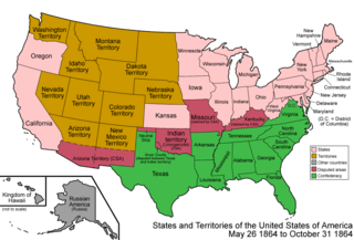
Description: Map of the states and territories of the United States as it was from May 1864 to October 1864. On May 26 1864, Montana Territory was split from Idaho Territory, which further lost some land to Dakota Territory. On October 31 1864, Nevada Territory was admitted as the state of Nevada.
Title: United States 1864-05-1864-10
Credit: Own work
Author: Made by User:Golbez.
Permission: Own work, attribution required (Multi-license with GFDL and Creative Commons CC-BY 2.5)
Usage Terms: Creative Commons Attribution 2.5
License: CC BY 2.5
License Link: http://creativecommons.org/licenses/by/2.5
Attribution Required?: Yes
Image usage

All content from Kiddle encyclopedia articles (including the article images and facts) can be freely used under Attribution-ShareAlike license, unless stated otherwise.