
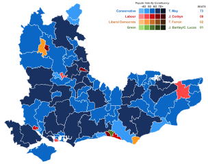
Image: United Kingdom General Election 2017 Results Map (South East England)

Size of this PNG preview of this SVG file: 758 × 599 pixels. Other resolution: 304 × 240 pixels.
Original image (SVG file, nominally 1,758 × 1,390 pixels, file size: 1.05 MB)
Description: United Kingdom General Election 2017 Results Map (South East England)
Title: United Kingdom General Election 2017 Results Map (South East England)
Credit: Own work
Author: DrRandomFactor
Usage Terms: Creative Commons Attribution-Share Alike 4.0
License: CC BY-SA 4.0
License Link: https://creativecommons.org/licenses/by-sa/4.0
Attribution Required?: Yes
Image usage
The following page links to this image:

All content from Kiddle encyclopedia articles (including the article images and facts) can be freely used under Attribution-ShareAlike license, unless stated otherwise.
.svg)