
Image: Umars jihad state map general c1864
No higher resolution available.
Umars_jihad_state_map_general_c1864.png (450 × 228 pixels, file size: 20 KB, MIME type: image/png)
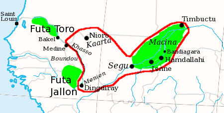
Description: General outline (red) of El-Hadj Umar Tall's jihad state at the time of his death (1864), at the empire's greatest extent. Covering much of modern Mali, as well as parts of Guinea and Mauritania
Title: Umars jihad state map general c1864
Credit: Own work
Author: T L Miles
Usage Terms: Creative Commons Attribution-Share Alike 3.0
License: CC BY-SA 3.0
License Link: https://creativecommons.org/licenses/by-sa/3.0
Attribution Required?: Yes
Image usage
The following page links to this image:

All content from Kiddle encyclopedia articles (including the article images and facts) can be freely used under Attribution-ShareAlike license, unless stated otherwise.