
Image: US federal land.agencies

Size of this PNG preview of this SVG file: 776 × 600 pixels. Other resolution: 311 × 240 pixels.
Original image (SVG file, nominally 990 × 765 pixels, file size: 3.65 MB)
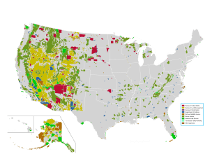
Description: Map of all federally owned land in the United States.
Title: US federal land.agencies
Credit: http://nationalatlas.gov/printable/fedlands.html, "All Federal and Indian Lands"
Author: National Atlas of the United States
Usage Terms: Public domain
License: Public domain
Attribution Required?: No
Image usage
The following 5 pages link to this image:

All content from Kiddle encyclopedia articles (including the article images and facts) can be freely used under Attribution-ShareAlike license, unless stated otherwise.