
Image: Tshwane population density map

Size of this PNG preview of this SVG file: 675 × 599 pixels. Other resolution: 270 × 240 pixels.
Original image (SVG file, nominally 919 × 816 pixels, file size: 1.04 MB)
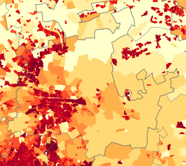
Description: Population density map of the City of Tshwane, Gauteng, South Africa, from the 2011 Census, at the "Small Area" level.
<1 inhabitant/km²
1–3 inhabitants/km²
3–10 inhabitants/km²
10–30 inhabitants/km²
30–100 inhabitants/km²
100–300 inhabitants/km²
300–1000 inhabitants/km²
1000–3000 inhabitants/km²
>3000 inhabitants/km²
Usage Terms: Public domain
Image usage
The following page links to this image:

All content from Kiddle encyclopedia articles (including the article images and facts) can be freely used under Attribution-ShareAlike license, unless stated otherwise.