
Image: Tennessee-goodspeed-map-detail-tn1
No higher resolution available.
Tennessee-goodspeed-map-detail-tn1.jpg (301 × 185 pixels, file size: 25 KB, MIME type: image/jpeg)
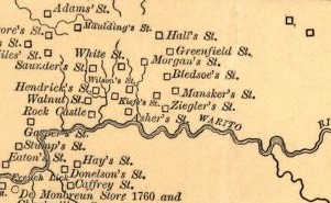
Description: Detail of Goodspeed's 1886 "Aboriginal Map of Tennessee" showing various 18th-century forts and settlements in the Upper Cumberland region.
Title: Tennessee-goodspeed-map-detail-tn1
Credit: http://lcweb2.loc.gov/cgi-bin/map_item.pl?data=/home/www/data/gmd/gmd396/g3961/g3961e/ct001216.jp2&itemLink=D?gmd:4:./temp/~ammem_F894::&title=Aboriginal+map+of+Tennessee+/+copyrighted+by+the+Goodspeed+Publishing+Co.&style=gmd&legend=
Author: Goodspeed Publishing Company
Usage Terms: Public domain
License: Public domain
Attribution Required?: No
Image usage
The following 2 pages link to this image:

All content from Kiddle encyclopedia articles (including the article images and facts) can be freely used under Attribution-ShareAlike license, unless stated otherwise.