
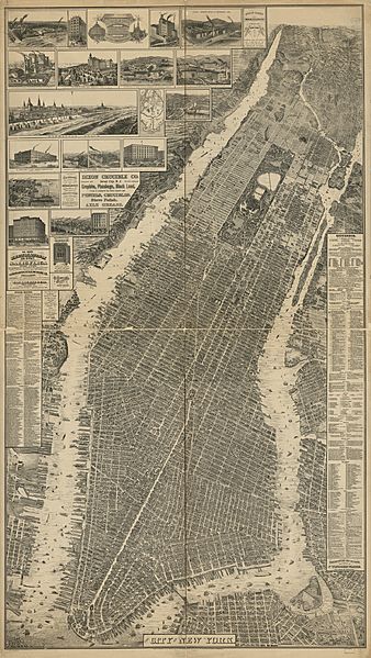
Image: Taylor map of New York

Size of this preview: 338 × 599 pixels. Other resolutions: 135 × 240 pixels | 12,901 × 22,870 pixels.
Original image (12,901 × 22,870 pixels, file size: 83.65 MB, MIME type: image/jpeg)
Description: The city of New York. Will L. Taylor, chief draughtsman. CREATED/PUBLISHED New York, Galt & Hoy, 1879. NOTES Perspective map not drawn to scale. Bird's-eye-view. Reference: LC Panoramic maps (2nd ed.), 599 Includes illus., index to points of interest, directory, view of "Manhattan Beach," and map "New York & Manhattan Beach R.R. & branches." MEDIUM map 188 x 107 cm. on 4 sheets 97 x 55 cm. CALL NUMBER G3804.N4A3 1879 .T3
Title: Taylor map of New York
Credit: http://hdl.loc.gov/loc.gmd/g3804n.pm005990
Author: Will L Taylor
Usage Terms: Public domain
License: Public domain
Attribution Required?: No
Image usage
The following 2 pages link to this image:

All content from Kiddle encyclopedia articles (including the article images and facts) can be freely used under Attribution-ShareAlike license, unless stated otherwise.