
Image: Syrian, Iraqi, and Lebanese insurgencies

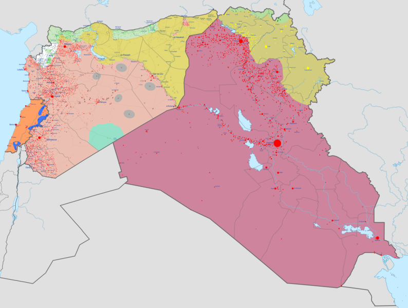
Description: Map of the Syrian Civil War, the Iraq Civil War (2014–present), and the Lebanese insurgency. For previous revisions of the battle map (not including Lebanon) before June 2015, see File:Syria and Iraq 2014-onward War map.png. After updating this map, please also update the date(s) at w:Module:Iraq Syria map date, used to denote the date in articles. Controlled by the Syrian Arab Republic (SAA) Controlled by the Iraqi government Controlled by the Syrian Interim Government (SNA) and Turkish Armed Forces, see Turkish occupation of northern Syria Controlled by Syrian Salvation Government (HTS) Former rebel areas that have reconciled with the Syrian government Controlled by the Islamic State of Iraq and the Levant (ISIL) Controlled by Rojava (SDF) Controlled by the Kurdistan Region Controlled by the Revolutionary Commando Army and United States Armed Forces Controlled by the Lebanese government Controlled by Hezbollah in Lebanon In the respective colours: Stable mixed control Rural presence Contested Strategic hill Oilfield/Gasfield Military base or checkpoint Airport/Air base (plane) Heliport/Helicopter base Major port or naval base Border post Dam Industrial complex
Title: Syrian, Iraqi, and Lebanese insurgencies
Credit: Own work Derivate of Syrian Civil War map.svg by Ecrusized, Iraqi Civil War map (2014–present).svg by Clyde H. Mapping and Lebanese insurgency.svg by Oganesson007.
Author: Ecrusized
Usage Terms: Creative Commons Zero, Public Domain Dedication
License: CC0
License Link: http://creativecommons.org/publicdomain/zero/1.0/deed.en
Attribution Required?: No
Image usage
The following 3 pages link to this image:
