
Image: Sulu Sultanate 1822

Size of this PNG preview of this SVG file: 800 × 400 pixels. Other resolution: 320 × 160 pixels.
Original image (SVG file, nominally 1,000 × 500 pixels, file size: 999 KB)
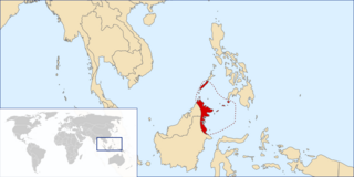
Description: Map showing the extent of the Sultanate of Sulu in 1822.
Title: Sulu Sultanate 1822
Credit: Own work based on.. The area from Kimanis Bay to the Paitan River not from Sulu but from Brunei (Brunei Museum, 1969) Sultan of Brunei cedes the lands east of Marudu Bay to the Sultanate of Sulu (1704) C.G Reichard's map
Author: Hariboneagle927, correction by Ranking Update
Usage Terms: Public domain
License: Public domain
Attribution Required?: No
Image usage
The following page links to this image:

All content from Kiddle encyclopedia articles (including the article images and facts) can be freely used under Attribution-ShareAlike license, unless stated otherwise.