
Image: SubsidedRoad

Size of this preview: 800 × 525 pixels. Other resolutions: 320 × 210 pixels | 948 × 622 pixels.
Original image (948 × 622 pixels, file size: 132 KB, MIME type: image/jpeg)
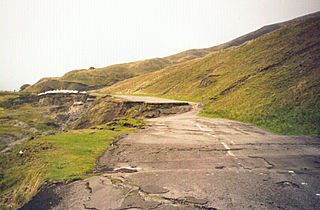
Description: A section of the en:A6187 road, near Castleton, UK, destroyed by geological subsidence. Now permanently closed. See en:Mam Tor, en:A625 road. See the plaque erected by the council for an explanation
Title: SubsidedRoad
Credit: Transferred from en.wikipedia to Commons.
Author: AJB83 at English Wikipedia
Usage Terms: Public domain
License: Public domain
Attribution Required?: No
Image usage
The following 2 pages link to this image:

All content from Kiddle encyclopedia articles (including the article images and facts) can be freely used under Attribution-ShareAlike license, unless stated otherwise.