
Image: Stmauricerivermap
No higher resolution available.
Stmauricerivermap.png (500 × 500 pixels, file size: 132 KB, MIME type: image/png)
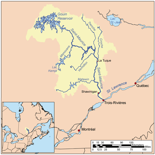
Description: This is a map of the Saint-Maurice River drainage basin, created based on USGS and Digital Chart of the World data. [1] used as reference.
Title: Stmauricerivermap
Credit: Own work
Author: Kmusser
Usage Terms: Creative Commons Attribution-Share Alike 2.5
License: CC BY-SA 2.5
License Link: https://creativecommons.org/licenses/by-sa/2.5
Attribution Required?: Yes
Image usage
The following 32 pages link to this image:
- Adolphe-Poisson Bay
- Atimokateiw River
- Blanche River (Ruban River tributary)
- Bostonnais River
- Bourgeois Lake
- Bouzanquet Bay
- Brochu Lake
- Bureau Lake
- Chapman Lake (Gouin Reservoir)
- De La Galette Lake
- De La Galette River
- Du Mâle Lake (Gouin Reservoir)
- Du Poète Lake
- Hanotaux Bay
- Jean-Pierre Bay
- Jean-Pierre River
- Kakospictikweak River
- Kikendatch Bay
- Leblanc River
- Mattawa Bay
- Miller Lake (Gouin Reservoir)
- Oskélanéo Lake
- Piciw Minikanan Bay
- Plamondon Bay
- Pokotciminikew River
- River Trenche
- Saint-Maurice River
- Saveney Lake
- Simard Lake (Gouin Reservoir)
- Tessier Lake
- Thibodeau Bay
- Vermillon River (La Tuque)

All content from Kiddle encyclopedia articles (including the article images and facts) can be freely used under Attribution-ShareAlike license, unless stated otherwise.