
Image: State of the Civil War in Yorkshire, January 1643
No higher resolution available.
State_of_the_Civil_War_in_Yorkshire,_January_1643.png (463 × 235 pixels, file size: 4 KB, MIME type: image/png)
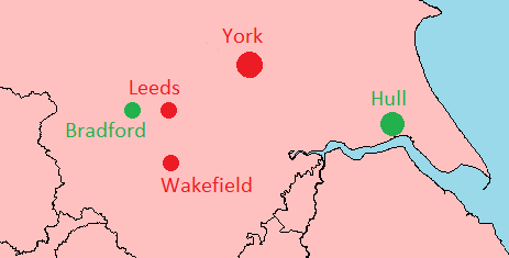
Description: A map showing the allegiance of the major towns in the south of Yorkshire prior to the capture of Leeds in January 1643. Towns in red are those held by the Royalists, and those in green by the Parliamentarians.
Title: State of the Civil War in Yorkshire, January 1643
Credit: Own work
Author: Harrias
Usage Terms: Creative Commons Attribution-Share Alike 3.0
License: CC BY-SA 3.0
License Link: https://creativecommons.org/licenses/by-sa/3.0
Attribution Required?: Yes
Image usage
The following page links to this image:

All content from Kiddle encyclopedia articles (including the article images and facts) can be freely used under Attribution-ShareAlike license, unless stated otherwise.