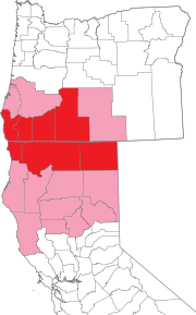
Image: State of Jefferson
State_of_Jefferson.png (180 × 289 pixels, file size: 30 KB, MIME type: image/png)
Description: Map of Oregon and northern California showing counties proposed for inclusion in the State of Jefferson in 1941.made this with Illustrator, the map vector outlines were extracted from public domain National Atlas congressional district maps.
Title: State of Jefferson
Credit: Uploaded from english WP [w:en:State of Jefferson.svg]
Author: User:IMeowbot
Usage Terms: Public domain
License: Public domain
Attribution Required?: No
Image usage
The following page links to this image:

All content from Kiddle encyclopedia articles (including the article images and facts) can be freely used under Attribution-ShareAlike license, unless stated otherwise.

