
Image: StJordansChapel

Size of this preview: 680 × 599 pixels. Other resolutions: 272 × 240 pixels | 1,010 × 890 pixels.
Original image (1,010 × 890 pixels, file size: 528 KB, MIME type: image/png)
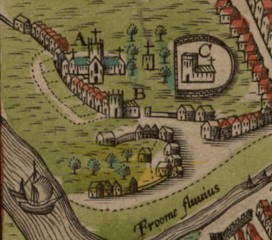
Description: Close-up of John Speed's map from 1610 showing the building that had previously been the chapel of St. Jordan, located between Bristol Cathedral (A) on the left and St. Mark's Church (C) on the right.
Title: StJordansChapel
Credit: Screenshot of a map made before 1610.
Author: Unknown printer from a map originally created by John Speed before 1610.
Usage Terms: Public domain
License: Public domain
Attribution Required?: No
Image usage
The following page links to this image:

All content from Kiddle encyclopedia articles (including the article images and facts) can be freely used under Attribution-ShareAlike license, unless stated otherwise.