
Image: Spitsbergen Norway's largest island

Size of this preview: 599 × 599 pixels. Other resolutions: 240 × 240 pixels | 3,539 × 3,540 pixels.
Original image (3,539 × 3,540 pixels, file size: 8.43 MB, MIME type: image/jpeg)
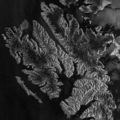
Description: Spitsbergen, Norway’s largest island, is pictured in this image, acquired on 6 September 2011 by Envisat’s Advanced Synthetic Aperture Radar (ASAR). Bordered by the Arctic Ocean to its north and the Greenland Sea to its west, Spitsbergen is the largest and only permanently populated island of the Svalbard archipelago.
Title: Spitsbergen, Norway’s largest island
Credit: http://www.esa.int/spaceinimages/Images/2011/10/Spitsbergen_Norway_s_largest_island
Author: Envisat satellite
Usage Terms: Creative Commons Attribution-Share Alike 3.0 igo
License: CC BY-SA 3.0 igo
License Link: https://creativecommons.org/licenses/by-sa/3.0/igo/deed.en
Attribution Required?: Yes
Image usage
The following 3 pages link to this image:

All content from Kiddle encyclopedia articles (including the article images and facts) can be freely used under Attribution-ShareAlike license, unless stated otherwise.