
Image: Southern British Isles 9th century

Size of this PNG preview of this SVG file: 629 × 435 pixels. Other resolution: 320 × 221 pixels.
Original image (SVG file, nominally 629 × 435 pixels, file size: 1.95 MB)
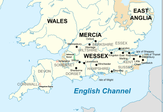
Description: Map of the Southern British Isles during the 9th century
Title: Southern British Isles 9th century
Credit: Own work Incorporates elements of this map. Locations are based on the Ordinance Survey Atlas of Great Britain, apart from Selwood Forest, which is taken from Barbara Yorke, Wessex in the Early Middle Ages, 1995, p. 23, ISBN 0 7185 1856 X
Author: Philg88; Attribution: Wikimedia Foundation (www.wikimedia.org)
Permission: This W3C-unspecified vector image was created with Adobe Illustrator.
Usage Terms: Creative Commons Attribution 4.0
License: CC BY 4.0
License Link: https://creativecommons.org/licenses/by/4.0
Attribution Required?: Yes
Image usage
The following 4 pages link to this image:

All content from Kiddle encyclopedia articles (including the article images and facts) can be freely used under Attribution-ShareAlike license, unless stated otherwise.