
Image: South Wales Map

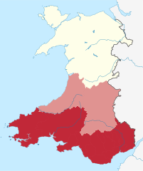
Description: Map of the undefined region of South Wales, following the borders of the common definitions of South East Wales and South West Wales. Ceredigion, Breconshire and Radnorshire (latter two are part of Powys) are shaded in a lighter tone as they are sometimes considered Mid Wales, but historically defined as South Wales. All areas coloured with red and pale red are the historic definition of South Wales. Other modern definitions may have a smaller definition.
Title: South Wales Map
Credit: This vector image includes elements that have been taken or adapted from this file:
Author: Dank · Jay
Usage Terms: Creative Commons Attribution-Share Alike 4.0
License: CC BY-SA 4.0
License Link: https://creativecommons.org/licenses/by-sa/4.0
Attribution Required?: Yes
Image usage
The following page links to this image:
