
Image: SouthAfrica1885

Size of this PNG preview of this SVG file: 716 × 600 pixels. Other resolution: 287 × 240 pixels.
Original image (SVG file, nominally 1,713 × 1,435 pixels, file size: 47 KB)
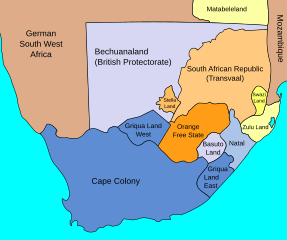
Description: Map of South Africa in July 1885, showing British possessions and protectorates, the two Boer Republics (i.e. Transvaal or SAR, and Orange Free State), besides German South West Africa and Portuguese Mozambique, or Province of Mozambique at the time
Title: SouthAfrica1885
Credit: SouthAfrica1885.jpg
Author: SouthAfrica1885.jpg: John George Bartholomew derivative work: Themightyquill (talk)
Usage Terms: Creative Commons Attribution-Share Alike 3.0
License: CC BY-SA 3.0
License Link: https://creativecommons.org/licenses/by-sa/3.0
Attribution Required?: Yes
Image usage
The following 4 pages link to this image:

All content from Kiddle encyclopedia articles (including the article images and facts) can be freely used under Attribution-ShareAlike license, unless stated otherwise.